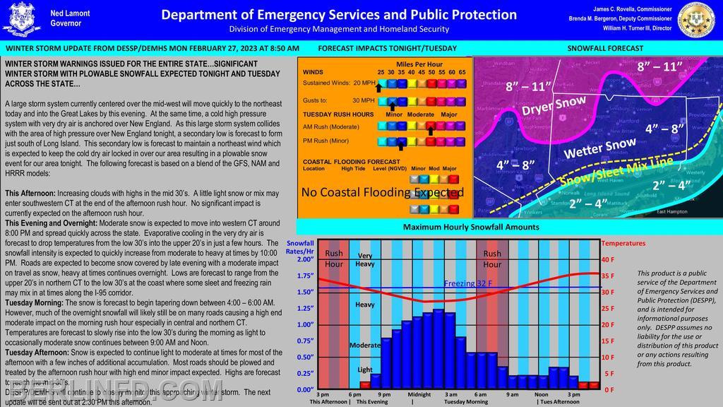
| WINTER STORM WARNINGS ISSUED FOR THE ENTIRE STATE…SIGNIFICANT WINTER STORM WITH PLOWABLE SNOWFALL EXPECTED TONIGHT AND TUESDAY ACROSS THE STATE…
A large storm system currently centered over the mid-west will move quickly to the northeast today and into the Great Lakes by this evening. At the same time, a cold high pressure system with very dry air is anchored over New England. As this large storm system collides with the area of high pressure over New England tonight, a secondary low is forecast to form just south of Long Island. This secondary low is forecast to maintain a northeast wind which is expected to keep the cold dry air locked in over our area resulting in a plowable snow event for our area tonight. The following forecast is based on a blend of the GFS, NAM and HRRR models:
This Afternoon: Increasing clouds with highs in the mid 30’s. A little light snow or mix may enter southwestern CT at the end of the afternoon rush hour. No significant impact is currently expected on the afternoon rush hour.
This Evening and Overnight: Moderate snow is expected to move into western CT around 8:00 PM and spread quickly across the state. Evaporative cooling in the very dry air is forecast to drop temperatures from the low 30’s into the upper 20’s in just a few hours. The snowfall intensity is expected to quickly increase from moderate to heavy at times by 10:00 PM. Roads are expected to become snow covered by late evening with a moderate impact on travel as snow, heavy at times continues overnight. Lows are forecast to range from the upper 20’s in northern CT to the low 30’s at the coast where some sleet and freezing rain may mix in at times along the I-95 corridor.
Tuesday Morning: The snow is forecast to begin tapering down between 4:00 – 6:00 AM. However, much of the overnight snowfall will likely still be on many roads causing a high end moderate impact on the morning rush hour especially in central and northern CT. Temperatures are forecast to slowly rise into the low 30’s during the morning as light to occasionally moderate snow continues between 9:00 AM and Noon.
Tuesday Afternoon: Snow is expected to continue light to moderate at times for most of the afternoon with a few inches of additional accumulation. Most roads should be plowed and treated by the afternoon rush hour with high end minor impact expected. Highs are forecast to reach the mid 30’s.
DESPP/DEMHS will continue to closely monitor this approaching winter storm. |