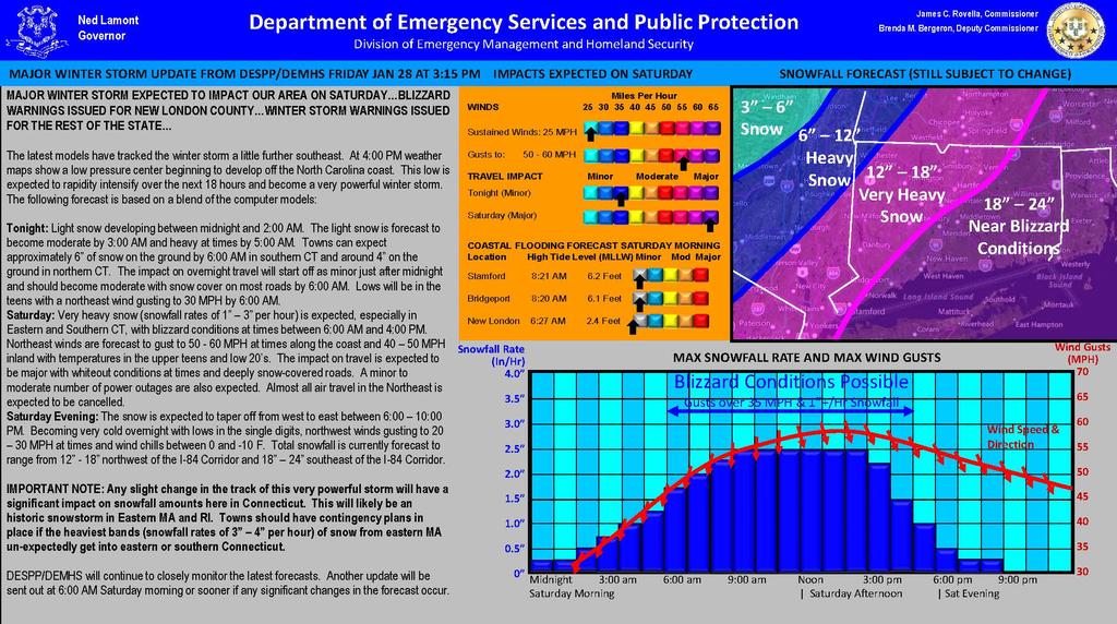
| MAJOR WINTER STORM EXPECTED TO IMPACT OUR AREA ON SATURDAY…BLIZZARD WARNINGS ISSUED FOR NEW LONDON COUNTY…WINTER STORM WARNINGS ISSUED FOR THE REST OF THE STATE…
The latest models have tracked the winter storm a little further southeast. At 4:00 PM weather maps show a low pressure center beginning to develop off the North Carolina coast. This low is expected to rapidity intensify over the next 18 hours and become a very powerful winter storm. The following forecast is based on a blend of the computer models:
Tonight: Light snow developing between midnight and 2:00 AM. The light snow is forecast to become moderate by 3:00 AM and heavy at times by 5:00 AM. Towns can expect approximately 6” of snow on the ground by 6:00 AM in southern CT and around 4” on the ground in northern CT. The impact on overnight travel will start off as minor just after midnight and should become moderate with snow cover on most roads by 6:00 AM. Lows will be in the teens with a northeast wind gusting to 30 MPH by 6:00 AM.
Saturday: Very heavy snow (snowfall rates of 1” –3” per hour) is expected, especially in Eastern and Southern CT, with blizzard conditions at times between 6:00 AM and 4:00 PM. Northeast winds are forecast to gust to 50 -60 MPH at times along the coast and 40 –50 MPH inland with temperatures in the upper teens and low 20’s. The impact on travel is expected to be major with whiteout conditions at times and deeply snow-covered roads. A minor to moderate number of power outages are also expected. Almost all air travel in the Northeast is expected to be cancelled.
Saturday Evening: The snow is expected to taper off from west to east between 6:00 –10:00 PM. Becoming very cold overnight with lows in the single digits, northwest winds gusting to 20 –30 MPH at times and wind chills between 0 and -10 F. Total snowfall is currently forecast to range from 12” -18” northwest of the I-84 Corridor and 18” –24” southeast of the I-84 Corridor.
IMPORTANT NOTE: Any slight change in the track of this very powerful storm will have a significant impact on snowfall amounts here in Connecticut. This will likely be an historic snowstorm in Eastern MA and RI. Towns should have contingency plans in place if the heaviest bands (snowfall rates of 3” –4” per hour) of snow from eastern MA un-expectedly get into eastern or southern Connecticut.
DESPP/DEMHS will continue to closely monitor this potentially major winter storm. |