| WINTER STORM WATCHES REMAIN IN EFFECT FOR NORTHERN CT…WINTER WEATHER ADVISORIES HAVE BEEN ISSUED FOR SOUTHERN CT…MODERATE WINTER STORM EXPECTED ON FRIDAY…
The NWS has issued Winter Storm Watches for Litchfield, Hartford, Tolland and Windham counties and Winter Weather Advisories for Fairfield, New Haven, Middlesex and New London counties. A large low pressure system is expected to start forming in West Virginia this evening and move northeast towards New York state. A weaker low pressure system is forecast to form off the Del-Mar-Va Peninsula at the same time and move towards Long Island. Neither of these low pressure systems is expected to be very strong, however they will both converge to bring a lot of precipitation into New England. Enough cold air is expected to be anchored over our area for the precipitation to start as a 6 – 9 hour period of moderate to heavy snow followed by a change to sleet and rain. The following forecast is based on a blend of the GFS, NAM and NWS forecasts:
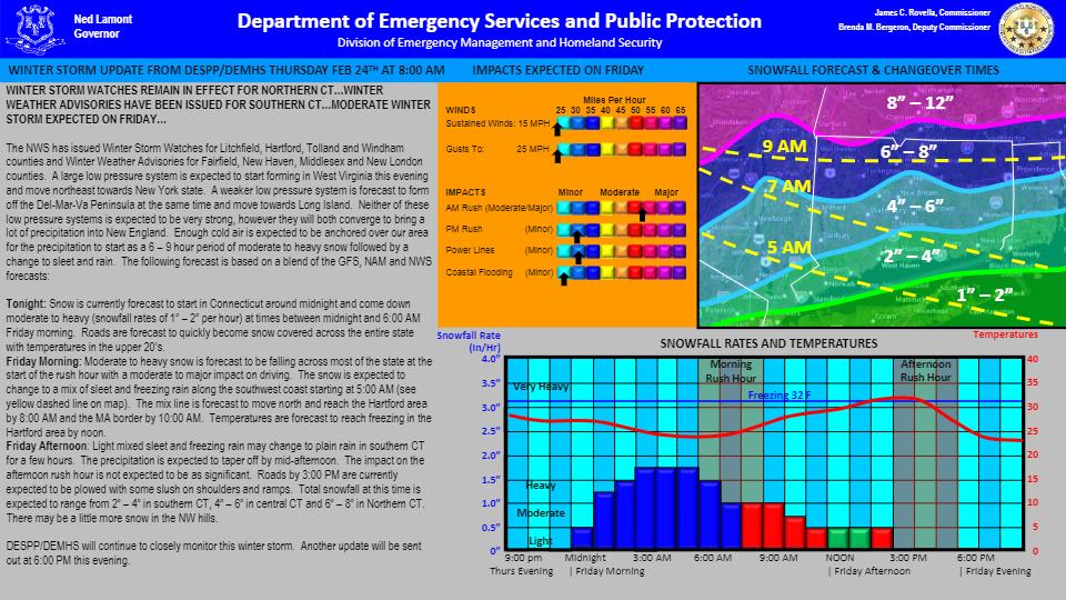
Tonight: Snow is currently forecast to start in Connecticut around midnight and come down moderate to heavy (snowfall rates of 1” – 2” per hour) at times between midnight and 6:00 AM Friday morning. Roads are forecast to quickly become snow covered across the entire state with temperatures in the upper 20’s.
Friday Morning: Moderate to heavy snow is forecast to be falling across most of the state at the start of the rush hour with a moderate to major impact on driving. The snow is expected to change to a mix of sleet and freezing rain along the southwest coast starting at 5:00 AM (see yellow dashed line on map). The mix line is forecast to move north and reach the Hartford area by 8:00 AM and the MA border by 10:00 AM. Temperatures are forecast to reach freezing in the Hartford area by noon.
Friday Afternoon: Light mixed sleet and freezing rain may change to plain rain in southern CT for a few hours. The precipitation is expected to taper off by mid-afternoon. The impact on the afternoon rush hour is not expected to be as significant. Roads by 3:00 PM are currently expected to be plowed with some slush on shoulders and ramps. Total snowfall at this time is expected to range from 2” – 4” in southern CT, 4” – 6” in central CT and 6” – 8” in Northern CT. There may be a little more snow in the NW hills.
DESPP/DEMHS will continue to closely monitor this winter storm. |