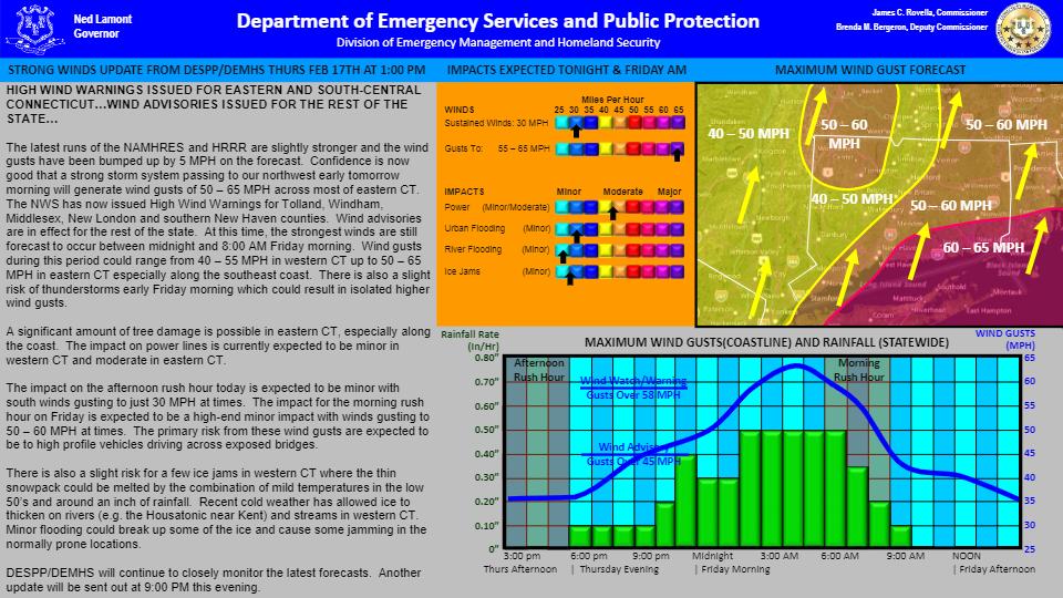
| HIGH WIND WARNINGS ISSUED FOR EASTERN AND SOUTH-CENTRAL CONNECTICUT…WIND ADVISORIES ISSUED FOR THE REST OF THE STATE FOR TONIGHT AND FRIDAY MORNING.
The latest runs of the NAMHRES and HRRR are slightly stronger and the wind gusts have been bumped up by 5 MPH on the forecast. Confidence is now good that a strong storm system passing to our northwest early tomorrow morning will generate wind gusts of 50 – 65 MPH across most of eastern CT. The NWS has now issued High Wind Warnings for Tolland, Windham, Middlesex, New London and southern New Haven counties. Wind advisories are in effect for the rest of the state. At this time, the strongest winds are still forecast to occur between midnight and 8:00 AM Friday morning. Wind gusts during this period could range from 40 – 55 MPH in western CT up to 50 – 65 MPH in eastern CT especially along the southeast coast. There is also a slight risk of thunderstorms early Friday morning which could result in isolated higher wind gusts.
A significant amount of tree damage is possible in eastern CT, especially along the coast. The impact on power lines is currently expected to be minor in western CT and moderate in eastern CT.
The impact on the afternoon rush hour today is expected to be minor with south winds gusting to just 30 MPH at times. The impact for the morning rush hour on Friday is expected to be a high-end minor impact with winds gusting to 50 – 60 MPH at times. The primary risk from these wind gusts are expected to be to high profile vehicles driving across exposed bridges.
There is also a slight risk for a few ice jams in western CT where the thin snowpack could be melted by the combination of mild temperatures in the low 50’s and around an inch of rainfall. Recent cold weather has allowed ice to thicken on rivers (e.g. the Housatonic near Kent) and streams in western CT. Minor flooding could break up some of the ice and cause some jamming in the normally prone locations.
DESPP/DEMHS will continue to closely monitor the latest forecasts. |