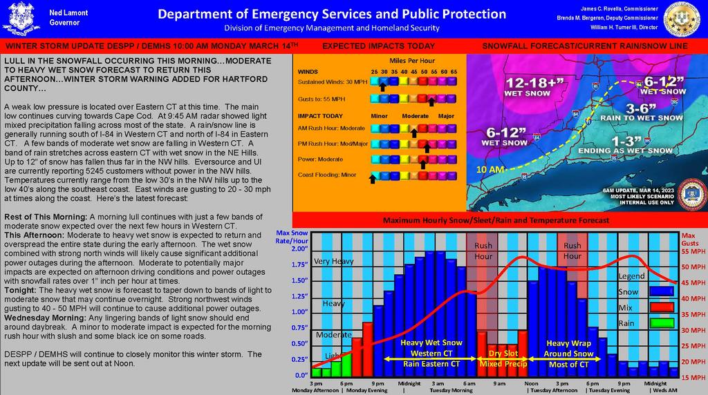
| LULL IN THE SNOWFALL OCCURRING THIS MORNING…MODERATE TO HEAVY WET SNOW FORECAST TO RETURN THIS AFTERNOON…WINTER STORM WARNING ADDED FOR HARTFORD COUNTY…
A weak low pressure is located over Eastern CT at this time. The main low continues curving towards Cape Cod. At 9:45 AM radar showed light mixed precipitation falling across most of the state. A rain/snow line is generally running south of I-84 in Western CT and north of I-84 in Eastern CT. A few bands of moderate wet snow are falling in Western CT. A band of rain stretches across eastern CT with wet snow in the NE Hills. Up to 12” of snow has fallen thus far in the NW hills. Eversource and UI are currently reporting 5245 customers without power in the NW hills. Temperatures currently range from the low 30’s in the NW hills up to the low 40’s along the southeast coast. East winds are gusting to 20 - 30 mph at times along the coast. Here’s the latest forecast:
Rest of This Morning: A morning lull continues with just a few bands of moderate snow expected over the next few hours in Western CT.
This Afternoon: Moderate to heavy wet snow is expected to return and overspread the entire state during the early afternoon. The wet snow combined with strong north winds will likely cause significant additional power outages during the afternoon. Moderate to potentially major impacts are expected on afternoon driving conditions and power outages with snowfall rates over 1” inch per hour at times.
Tonight: The heavy wet snow is forecast to taper down to bands of light to moderate snow that may continue overnight. Strong northwest winds gusting to 40 - 50 MPH will continue to cause additional power outages.
Wednesday Morning: Any lingering bands of light snow should end around daybreak. A minor to moderate impact is expected for the morning rush hour with slush and some black ice on some roads.
DESPP / DEMHS will continue to closely monitor this winter storm. |