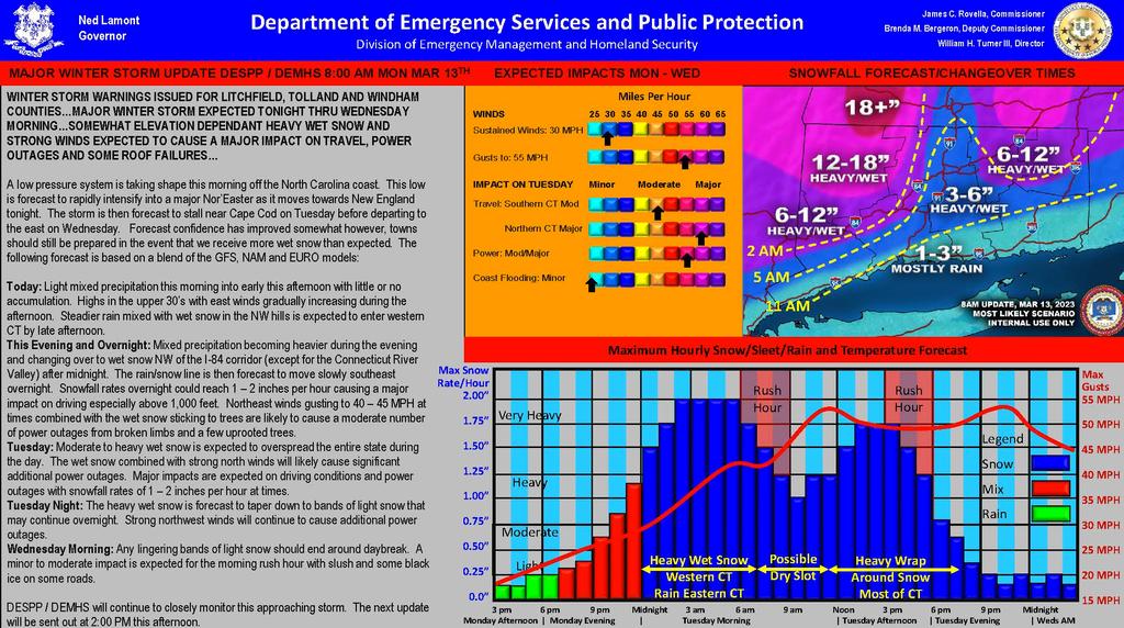
| WINTER STORM WARNINGS ISSUED FOR LITCHFIELD, TOLLAND AND WINDHAM COUNTIES…MAJOR WINTER STORM EXPECTED TONIGHT THRU WEDNESDAY MORNING…SOMEWHAT ELEVATION DEPENDANT HEAVY WET SNOW AND STRONG WINDS EXPECTED TO CAUSE A MAJOR IMPACT ON TRAVEL, POWER OUTAGES AND SOME ROOF FAILURES…
A low pressure system is taking shape this morning off the North Carolina coast. This low is forecast to rapidly intensify into a major Nor’Easter as it moves towards New England tonight. The storm is then forecast to stall near Cape Cod on Tuesday before departing to the east on Wednesday. Forecast confidence has improved somewhat however, towns should still be prepared in the event that we receive more wet snow than expected. The following forecast is based on a blend of the GFS, NAM and EURO models:
Today: Light mixed precipitation this morning into early this afternoon with little or no accumulation. Highs in the upper 30’s with east winds gradually increasing during the afternoon. Steadier rain mixed with wet snow in the NW hills is expected to enter western CT by late afternoon.
This Evening and Overnight: Mixed precipitation becoming heavier during the evening and changing over to wet snow NW of the I-84 corridor (except for the Connecticut River Valley) after midnight. The rain/snow line is then forecast to move slowly southeast overnight. Snowfall rates overnight could reach 1 – 2 inches per hour causing a major impact on driving especially above 1,000 feet. Northeast winds gusting to 40 – 45 MPH at times combined with the wet snow sticking to trees are likely to cause a moderate number of power outages from broken limbs and a few uprooted trees.
Tuesday: Moderate to heavy wet snow is expected to overspread the entire state during the day. The wet snow combined with strong north winds will likely cause significant additional power outages. Major impacts are expected on driving conditions and power outages with snowfall rates of 1 – 2 inches per hour at times.
Tuesday Night: The heavy wet snow is forecast to taper down to bands of light snow that may continue overnight. Strong northwest winds will continue to cause additional power outages.
Wednesday Morning: Any lingering bands of light snow should end around daybreak. A minor to moderate impact is expected for the morning rush hour with slush and some black ice on some roads.
DESPP / DEMHS will continue to closely monitor this approaching storm.
We will post updates as we receive them. |