| MAJOR WINTER STORM EXPECTED MONDAY NIGHT THRU WEDNESDAY MORNING…SOMEWHAT ELEVATION DEPENDANT HEAVY WET SNOW AND STRONG WINDS MAY CAUSE A MAJOR IMPACT ON TRAVEL, POWER OUTAGES, COASTAL FLOODING AND A FEW ROOF FAILURES…WINTER STORM WATCHES ISSUED FOR NORTHERN CT AND NORTHERN FAIRFIELD COUNTY…
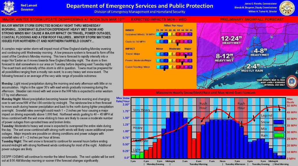
A complex major winter storm will impact most of New England starting Monday evening and continuing until Wednesday morning. A low pressure system is forecast to form off the coast of the Carolina’s Monday morning. This low is forecast to rapidly intensify into a major Nor’Easter as it moves towards New England Monday night. The storm is then forecast to stall somewhere in our area on Tuesday before departing east Tuesday night. The exact track and intensity of this storm is still in question. Towns must be prepared for all possibilities ranging from a mostly rain event, to a very heavy wet snow event. The following forecast is an average of the very wide range of possible outcomes:
Monday: Light mixed precipitation during the morning and early afternoon with little or no accumulation. Highs in the upper 30’s with east winds gradually increasing during the afternoon. Steadier rain mixed with wet snow in the NW hills is expected to enter western CT by mid afternoon.
Monday Night: Mixed precipitation becoming heavier during the evening and changing over to wet snow NW of the I-84 corridor by midnight. The rain/snow line is then forecast to move south during heavier precipitation and back to the north during lighter precipitation overnight. Snowfall rates overnight could reach 1 – 2 inches per hour causing a major impact on driving especially above 1,000 feet. Northeast winds gusting to 40 – 45 MPH at times combined with the wet snow sticking to trees are likely to cause a moderate number of power outages from uprooted trees and broken limbs.
Tuesday: Moderate to heavy wet snow is expected to overspread the entire state during the day. The wet snow combined with strong north winds will likely cause additional power outages. Major impacts are possible on driving conditions and power outages with snowfall rates of 1 – 2 inches per hour at times.
Tuesday Night: The wet snow is forecast to continue for several hours before ending around midnight with strong Northwest winds continuing for most of the night. Additional power outages are likely.
DESPP / DEMHS will continue to monitor the latest forecasts. |